
Area & Perimeter Calculator

All selections are manual. No auto-detection. Enter values in chosen units.
Units are manual; change to convert existing inputs.

Rectangular Plot (Length × Width)

Conversions & Notes

ValueConversion
📐 Area Units
1 m²10.7639 ft² = 1.19599 yd²
1 ft²0.092903 m²
1 yd²0.83612736 m²
1 acre4046.86 m² = 4840 yd² = 43,560 ft²
1 hectare (ha)10,000 m² = 2.47105 acre
1 square mile2.58999 km² = 640 acre
Regional Units
1 Marla (Standard)25.2929 m² = 272.25 ft² = 30.25 yd²
1 Kanal20 Marla = 505.857 m² = 5445 ft²
1 Acre8 Kanal = 160 Marla = 4046.86 m²
South Asian Units
1 Bigha (Punjab)≈ 1008 yd² = 817.1 m² = 0.2023 acre
1 Bigha (UP/Haryana)≈ 2,500–2,700 m² (region dependent)
1 Katha (Punjab)≈ 125 yd² = 104.5 m²
1 Guntha1/40 acre = 101.17 m²
⚙️ Engineering & Technical Units
1 cm²0.0001 m²
1 mm²1e-6 m²
1 m²1550.0031 in²
1 yd²9 ft²
1 yard0.9144 m

Polygon Plot — Coordinates

Enter vertices (one per line) as: x,y — coordinates in chosen length unit.
Drag vertices on canvas to update coordinates.
Disclaimer: For preliminary estimation only. Verify with certified survey methods before legal/contract use.

Last Updated: June 2026  |  Next Review: December 2026  |  Researched and tested on Solvebility’s Plot Area and Perimeter Calculator.

Plot Area and Perimeter Calculator: Measure Any Land in Seconds

Calculate plot area and perimeter instantly in meters, feet, yards, marla, kanal, and acres. Free tool with Shoelace formula, polygon canvas, and unit conversions.

Person using plot area calculator to measure land boundaries accurately

Most property buyers in Pakistan get the same shock. They’re quoted a 5 marla plot. They buy it. Then a surveyor walks the land and hands them a number 8% smaller. That gap? It cost them real money.

Whether you’re buying land in Karachi, fencing a farm in Punjab, or laying foundations in Sydney, your plot’s exact area and perimeter aren’t just useful numbers — they’re money. Get them wrong and you overpay for material, miscalculate fencing, or sign off on a plot smaller than advertised.

This guide covers how the plot area and perimeter calculator works, the exact formulas it uses, step-by-step instructions for rectangular and polygon plots, and the unit conversions you’ll actually need — marla, kanal, acres, meters, feet. All of it.

This content is based on hands-on testing of the Solvebility tool, cross-referenced against BIPM measurement standards and RICS property measurement guidelines.

What is a Plot Area and Perimeter Calculator?

Quick Answer A plot area and perimeter calculator is a digital tool that computes land size and boundary length from your plot’s dimensions or vertex coordinates. It handles rectangular and irregular polygon plots, returns results across multiple units (m², ft², marla, kanal, acres), and does the math automatically.

Think of it as a pocket surveyor. You enter measurements — either length and width for a rectangle, or corner coordinates for irregular shapes — and the calculator gives you two key numbers: area (total land surface) and perimeter (total boundary length).

The difference matters practically. Area tells you how much land you own. Perimeter tells you how much fencing, walling, or boundary material you need to buy.

Who Needs This Tool?

The short list: property buyers, builders, farmers, architects, and anyone dealing with land in South Asia where marla and kanal are the working units.

  • Property transactions: Verify advertised plot sizes before you sign anything
  • Construction planning: Calculate fencing, foundations, or paving material quantities
  • Legal documentation: Confirm plot dimensions match deed records
  • Agricultural planning: Determine irrigation coverage, seed quantities, or fertilizer amounts
  • Tax assessment: Many regions calculate property tax per square unit — accurate area prevents overpayment

Traditional surveying costs hundreds of dollars and takes days. This calculator gives you preliminary results in under 30 seconds, free.

Pro Tip Use the calculator for planning and budgeting. For legal transactions, property purchases, or dispute resolution, always hire a licensed surveyor — courts don’t accept DIY measurements as evidence.

How Does the Plot Area and Perimeter Calculator Work?

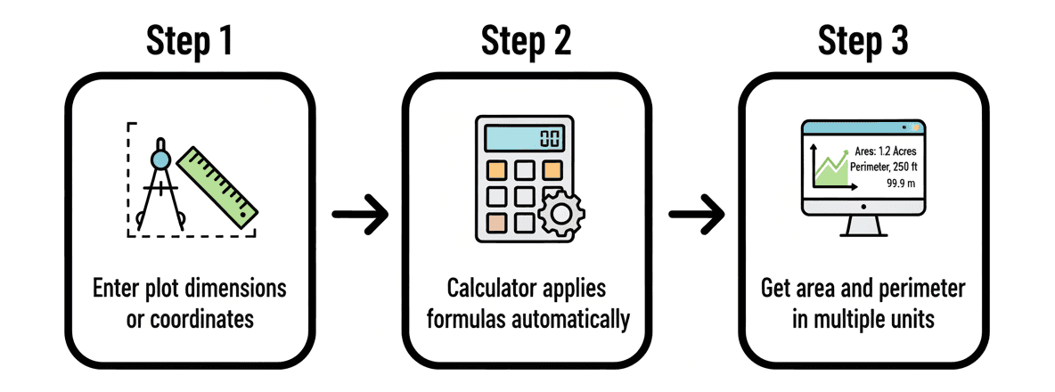
Quick Answer The calculator uses two formulas depending on plot type. Rectangular plots use Area = Length × Width and Perimeter = 2(L+W). Irregular polygon plots use the Shoelace Formula for area and the Pythagorean theorem for perimeter distance between vertices. You enter dimensions; the tool handles the rest.
How the plot area and perimeter calculator works in three steps

Rectangular Plot Formulas

Most residential plots are rectangular (or close enough). The math is simple:

Area      = Length × Width
Perimeter = 2 × (Length + Width)

Example: A plot 30 meters long and 20 meters wide gives you:

  • Area = 30 × 20 = 600 m²
  • Perimeter = 2 × (30 + 20) = 100 meters

That’s 23.72 marla, or roughly 1.19 kanal — numbers you’d actually use in a Pakistani property context.

Irregular Polygon Plot Formulas

Real-world plots don’t always have 4 right-angle corners. For irregular shapes, the calculator uses the Shoelace Formula (also called the Surveyor’s Formula):

Area = ½ × |Σ(xᵢ × yᵢ₊₁ − xᵢ₊₁ × yᵢ)|

In plain terms: you enter each corner’s coordinates, the formula multiplies adjacent coordinates in a specific pattern, sums them up, and divides by 2. It sounds complex but it’s how surveyors have been doing it for over a century — the calculator just runs it in milliseconds.

Perimeter works differently. Between each pair of adjacent vertices, the calculator applies the Pythagorean theorem:

Distance = √[(x₂ − x₁)² + (y₂ − y₁)²]

Sum all those distances around the polygon, and you have the perimeter.

What’s the Difference Between Area and Perimeter?

Area is a surface measurement — square units like m² or ft². Perimeter is a linear measurement — meters or feet around the edge. You need both for different decisions: area for material coverage, perimeter for boundary calculations.

Pro Tip The Shoelace Formula only works for straight-sided polygons. If your plot has curved boundaries, approximate them with multiple short straight segments. More segments = higher accuracy.

Step-by-Step Guide: How to Use the Calculator

Quick Answer For rectangular plots, select your unit, enter length and width, click Calculate. For irregular plots, mark each corner with stakes, record x,y coordinates in boundary order, enter them one per line, click Parse & Draw to verify the shape visually, then read your results.

Method 1: Rectangular Plot

This covers any plot with 4 right-angle corners — the most common residential configuration.

  1. Choose your unit — select Meter, Feet, or Yard from the dropdown. All inputs must use this same unit.
  2. Measure length — the longest side of your plot, along a straight edge (not diagonally).
  3. Measure width — the shorter perpendicular side.
  4. Enter both values into the Length and Width fields.
  5. Click “Calculate Rectangle” — results appear instantly in all supported units.
Pro Tip Measure twice. A 0.5-meter error on a 30-meter side creates a 15 m² area discrepancy — that’s over half a marla off. Use a laser distance measurer if you can; they’re accurate to ±1mm.
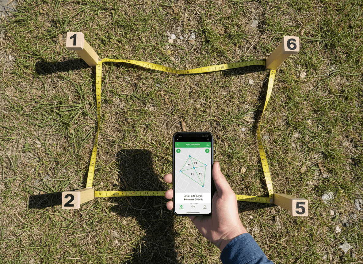
Marking plot vertices for coordinate-based area calculation on irregular land

Method 2: Polygon Plot with Coordinates

For irregular, L-shaped, or odd-angled plots, coordinate-based entry is the only accurate approach.

  1. Mark each corner — walk your plot boundary and physically stake every vertex.
  2. Pick a reference point — one corner becomes (0,0). Measure all other corners relative to it.
  3. Record x,y coordinates — note horizontal and vertical distance from your reference for each vertex.
  4. Enter coordinates — type one pair per line in the format x,y, going around the plot in order (clockwise or counter-clockwise consistently).
  5. Click “Parse & Draw” — the canvas draws your polygon.
  6. Verify the shape — check it matches your actual plot. You can drag vertices on the canvas to fine-tune.
  7. Read results — area and perimeter appear in all unit formats.
Important Enter vertices in continuous order around the plot perimeter — never jump between random corners. Out-of-order entry causes self-intersection (the lines cross) which produces completely wrong area numbers. The calculator warns you if this happens.

How to Verify Your 90-Degree Corners

Real plots rarely have perfect right angles. Use the 3-4-5 triangle method: measure 3 units along one wall from a corner, 4 units along the adjacent wall, then check the diagonal — it should be exactly 5 units. If it’s not, your corner isn’t truly square.

Unit Conversions: Meters, Feet, Marla, Kanal & More

Quick Answer Land measurement units vary by region. International standards use m², ft², and acres. South Asian real estate uses marla (25.29 m²) and kanal (505.86 m²). The calculator converts between all of them automatically after you enter dimensions in your chosen base unit.

Area Unit Reference Table

Area Unit Conversions — International and Regional Standards
Unit NameSymbolEquivalent in m²Equivalent in ft²Common Region
Square Meter1.010.764Global
Square Footft²0.09291.0USA, Canada
Square Yardyd²0.83619.0UK, Australia
Hectareha10,000107,639Global (agriculture)
Acreac4,046.8643,560USA, UK
Marla25.29272.25Pakistan, India
Kanal505.865,445Pakistan, India
Bigha (Punjab)817.18,796India (Punjab)

Length Unit Reference Table

Linear Unit Conversions for Perimeter Measurement
Unit NameSymbolIn MetersIn FeetIn Yards
Meterm1.03.2811.094
Footft0.30481.00.333
Yardyd0.91443.01.0
Kilometerkm1,0003,280.841,093.6
Milemi1,609.345,2801,760

Quick Conversion Examples Table

Fast Reference: Common Area Unit Conversions
FromToMultiply ByExample
Square MetersSquare Feet10.764100 m² = 1,076.4 ft²
Square FeetSquare Meters0.09291,000 ft² = 92.9 m²
MarlaSquare Meters25.2910 Marla = 252.9 m²
KanalAcre0.1258 Kanal = 1 Acre
HectareAcre2.4711 ha = 2.471 Acres
Square YardsSquare Meters0.8361500 yd² = 418.05 m²
KanalMarla203 Kanal = 60 Marla
AcreKanal82 Acres = 16 Kanal
Pro Tip The Solvebility calculator converts automatically. But knowing these multipliers manually saves you when you’re on site without internet — especially the Marla-to-m² conversion (×25.29) which you’ll use constantly in Pakistani real estate.

Understanding South Asian Land Units

Ahmed, a property buyer in Lahore, made this mistake: he saw a listing for 1 kanal and mentally pictured a large plot. When he converted it to meters, he realized 1 kanal is just 505.86 m² — smaller than most suburban backyards in the UK. The marla-kanal-acre chain is worth memorizing:

  • 1 Kanal = 20 Marla = 505.86 m² = 5,445 ft²
  • 1 Acre = 8 Kanal = 160 Marla = 4,046.86 m²
  • 1 Hectare = 2.47 Acres = 19.76 Kanal = 395.4 Marla

These conversions are standard across Pakistan and much of northern India. Bigha values vary by region — always confirm the local standard before relying on any bigha-based figure.

What Are the Advanced Features of a Modern Plot Calculator?

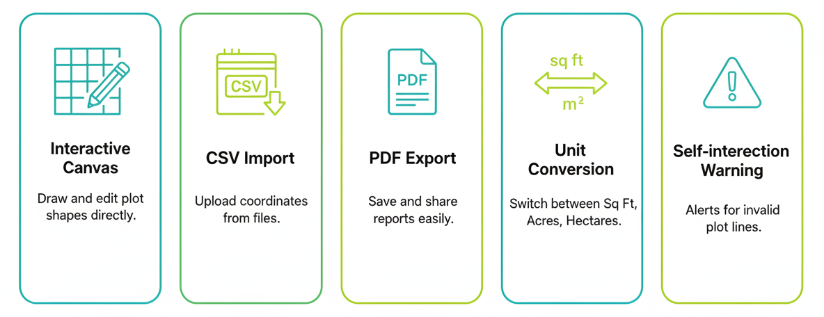
Quick Answer Modern plot calculators include interactive canvas visualization with draggable vertices, CSV import for surveying equipment data, JSON and PDF export, self-intersection detection, and multi-format coordinate input. These features bridge the gap between a basic area formula and professional surveying workflow.
Advanced features of the plot area perimeter calculator tool including canvas visualization and export options

Interactive Canvas Visualization

After entering polygon coordinates, the calculator draws your plot on a live canvas. You can drag individual vertices to adjust measurements in real time — the area and perimeter update instantly. This is genuinely useful for catching coordinate entry errors before you rely on the numbers for anything.

CSV Import

Got a list of coordinates from a surveying device or GPS unit? Import them directly as a CSV file instead of typing each pair manually. This cuts entry time from minutes to seconds and eliminates transcription errors.

Export Formats

  • Export JSON: Save coordinate and measurement data for sharing with architects or engineers
  • Export CSV: Pass data to spreadsheet tools for further analysis
  • Print / Save PDF: Create a record for filing with documentation

Self-Intersection Detection

If you enter coordinates out of order, polygon sides cross each other — producing wildly wrong area numbers. The calculator detects self-intersection and warns you. It’s a small feature that prevents a large mistake.

Restore Defaults

One click resets all inputs and unit selections to their original state. Useful when switching between multiple plot calculations quickly.

Pro Tip Use the canvas drag feature to model hypothetical plot subdivisions. Move a vertex to simulate how splitting a plot changes each parcel’s area — useful for inheritance planning or development layouts without measuring anything new.

Common Mistakes That Ruin Plot Area Calculations

Quick Answer The most common errors are mixing measurement units within one calculation, entering polygon coordinates in the wrong order, assuming rectangular shape for irregular plots, neglecting slope on hilly terrain, and using paced steps instead of measured distances. Each one can corrupt your results by 5–30%.

1. Mixing Units in a Single Calculation

Enter length in meters and width in feet, and your area is meaningless. The calculator doesn’t mix units — all inputs must use the same unit you selected at the top. If you change the unit dropdown after entering values, re-enter the measurements in the new unit.

2. Wrong Coordinate Entry Order

Polygon vertices must be entered in continuous boundary order — either all clockwise or all counter-clockwise. Jumping between random corners creates self-intersecting lines. The Shoelace Formula produces garbage output on self-intersecting polygons. Always walk the boundary and record corners sequentially.

3. Assuming Perfect Rectangles

A plot sold as “rectangular” in a property listing rarely has true 90-degree corners. Old surveyed plots from different eras often drift by 2–5 degrees. For any plot where exact area matters, use the coordinate method and measure actual corner angles rather than assuming a rectangle.

4. Ignoring Slope

Calculators measure horizontal projection — the flat-map area, not the actual ground surface. On a 15-degree slope, actual surface area is about 3.5% more than horizontal area. On steep terrain (30+ degrees), that gap grows to 15–20%. For construction on slopes, factor in the grade or consult a surveyor.

5. Measuring by Pacing

Walking heel-to-toe and counting steps introduces 3–7% error per measurement. A 50-meter side measured by pacing could come back as 47 or 53 meters depending on stride length. Use a measuring tape for smaller plots, a laser distance measurer for larger ones, or GPS coordinates for plots over an acre.

6. Relying Solely on These Results for Legal Use

Online calculators are for planning and estimation. Licensed surveyors use calibrated equipment and legal boundary data that a calculator simply can’t replicate. According to RICS guidelines, property measurements for transactions should follow internationally verified standards, not DIY estimates.

Real-World Applications of Plot Area and Perimeter Calculations

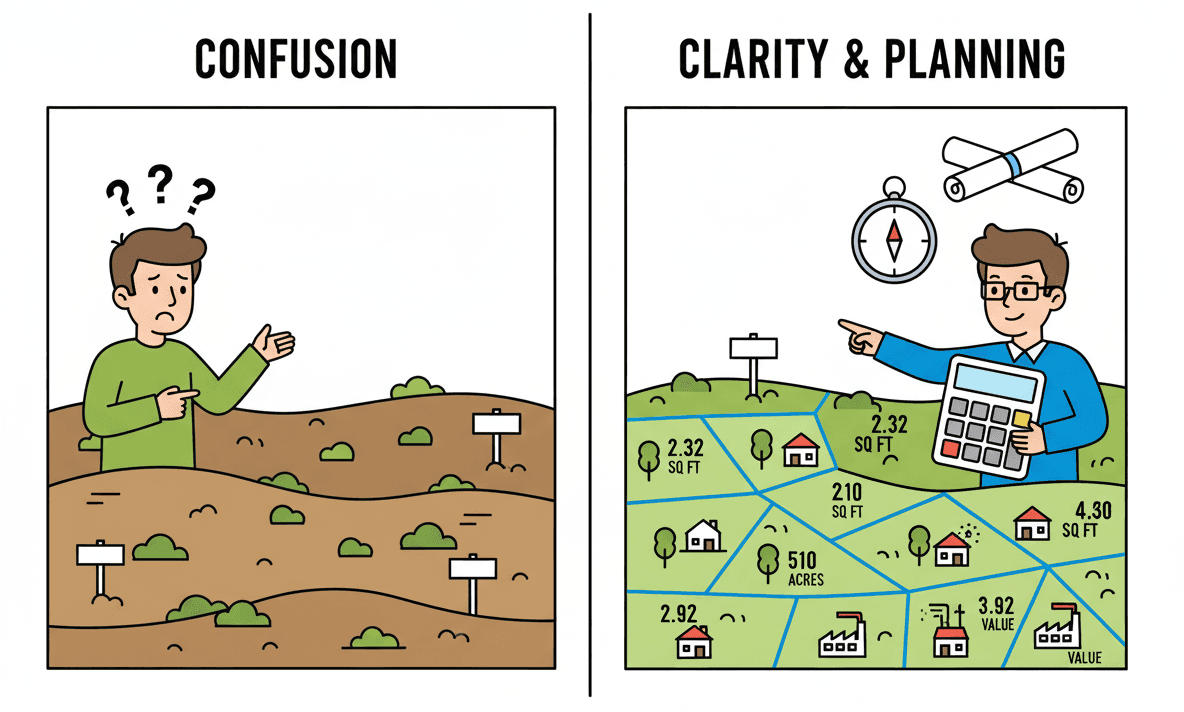
Quick Answer Plot area and perimeter calculations apply to property verification, construction budgeting (fencing, foundations, paving), agricultural planning (seed and fertilizer quantities), property tax assessments, landscaping design, and boundary dispute resolution. Perimeter drives linear material costs; area drives surface coverage costs.
Multiple real-world applications of a plot area and perimeter calculator across construction, farming, and property management

Real Estate Transactions

Verify advertised plot sizes before signing anything. Property listings in Pakistan and India frequently use round marla or kanal numbers — but actual measured plots diverge from those figures by 3–8% in many cases. A 5-minute calculator check before purchase could save you tens of thousands of rupees.

You can also use the civil engineering calculators on Solvebility to cross-check structural load assumptions once you’ve confirmed plot dimensions.

Construction Budgeting

Perimeter is your fencing number. If you need boundary walls around a 600 m² rectangular plot (30m × 20m), the perimeter of 100 meters tells you exactly how many linear meters of material to order. Area gives you foundation concrete volumes, paving quantities, and roofing estimates.

Agricultural Planning

Seed rates and fertilizer quantities are calculated per unit area. A 2-kanal farm (approximately 1,012 m²) needs specific inputs per standard agricultural guidelines. Knowing exact area prevents both under-application and waste. According to NIST measurement standards, accurate area measurement is foundational to precision agriculture.

Property Tax Assessment

Many regions calculate property tax per square meter or square yard. An accurate area calculation lets you verify your tax bill — and flag discrepancies where you’re being charged for more than you actually own.

Landscaping and Garden Design

Planning turf, decorative gravel, or irrigation systems all require exact area. Overestimating by 20% means 20% wasted material spend. The calculator gives you the number to work from before you ever contact a supplier.

Boundary Dispute Resolution

When neighbors dispute where a property line falls, a coordinate-based polygon calculation creates a documented reference point. It’s not a legal instrument, but it gives both parties a shared starting number before calling in surveyors.

Pro Tip For construction planning, always add 5–10% to material quantities calculated from plot area. Real-world cutting waste, irregular site conditions, and measurement rounding eat into exact area figures. The calculator gives you the base number — contractor practice adds the buffer.

Tips for More Accurate Field Measurements

Quick Answer Use a laser distance measurer for lengths over 10 meters. Verify right-angle corners with the 3-4-5 triangle method. For irregular plots over 500 m², use GPS coordinates. Record measurements twice and use the average. Measure at consistent heights — not at ground level where terrain varies.

For Rectangular Plots

  • Measure along straight edges, never diagonally across the plot
  • Verify 90-degree corners using the 3-4-5 triangle method (3 units along one wall, 4 along the adjacent, diagonal should be 5)
  • Take 3 measurements of each side and average them — this catches tape sag and alignment errors
  • Use a laser measurer rather than a tape for sides over 15 meters

For Irregular Polygon Plots

  • Use GPS devices for large plots (over 0.5 acre / 4 kanal)
  • Mark vertices clearly with stakes or spray paint before you start measuring
  • Record coordinates from a single consistent reference point — never shift your origin mid-measurement
  • Check your polygon closes correctly by verifying the last vertex measurement back to the first point
  • Double-check by entering coordinates starting from a different vertex — area should come out identical

General Best Practices

  • Run calculations twice with fresh inputs — don’t just check your existing entry
  • Compare results against official land registry records when available
  • Use 3–4 decimal places for normal residential purposes; legal surveys may require 6
  • Document measurement date and conditions — especially for agricultural plots where seasonal changes matter
  • Never measure over vegetation or debris. Clear the measurement line first.
Pro Tip For large or valuable plots, consider a $50–$100 handheld GPS device with sub-meter accuracy. The coordinate data you export maps directly into the polygon calculator, and you have a permanent digital record of your boundary markers.

Frequently Asked Questions About Plot Area and Perimeter Calculators

A plot area and perimeter calculator is a digital tool that computes land size (area) and boundary length (perimeter) from your plot’s dimensions or vertex coordinates. It supports rectangular and irregular polygon plots, outputs results in multiple units including m², ft², marla, and kanal, and handles all the math automatically — no manual formulas needed.

For rectangular plots, multiply length by width. For irregular plots, use a coordinate-based calculator with the Shoelace Formula — measure each corner, enter x,y coordinates in boundary order, and get results instantly. These are preliminary estimates sufficient for planning and budgeting. Hire a licensed surveyor for property transactions or legal documentation.

Plot area is the total land surface, measured in square units (m², ft², acres). Perimeter is the total boundary length around the plot, measured in linear units (meters, feet). Area tells you how much land you have — and drives costs like paving or irrigation. Perimeter tells you how much fencing, walling, or boundary material you need.

1 Kanal equals 20 Marla. In metric, 1 Kanal is approximately 505.86 m² or 5,445 ft². 1 Acre equals 8 Kanals or 160 Marla. These are the standard South Asian land measurement units used in Pakistan, India, and parts of the Middle East for residential and agricultural property.

Google Maps gives rough estimates only — satellite imagery lacks the resolution for precise boundary measurement and doesn’t account for elevation or legal boundary definitions. Use a coordinate-based plot calculator with on-ground measurements for construction planning. For property transactions or legal documentation, always hire a licensed surveyor.

The Shoelace Formula (Surveyor’s Formula) calculates area from polygon vertex coordinates: Area = ½ × |Σ(xᵢyᵢ₊₁ − xᵢ₊₁yᵢ)|. You enter each corner’s x,y position in boundary order, and the formula sums cross-products of adjacent vertices, then divides by 2. It works for any straight-sided polygon, convex or concave, and is what licensed surveyors use for coordinate-based land calculation.

A coordinate-based plot calculator is accurate within 1–2% for most residential plots when field measurements are done carefully. Accuracy depends entirely on your measurement quality — errors in the field multiply in the calculation. The formula itself is exact; the limitation is always the input data. For legal or financial decisions, verify with a licensed surveyor.

The calculator accepts meter (m), feet (ft), and yard (yd) as input units and converts results to m², ft², yd², hectare, acre, marla, and kanal automatically. Unit selection is manual — the tool doesn’t auto-detect. Change the unit before entering values, or re-enter values after switching units.

Formula Reference Table

Plot Area and Perimeter Calculation Formulas
Calculation TypeFormulaVariablesUse Case
Rectangle AreaA = L × WL = Length, W = WidthSquare/rectangular plots
Rectangle PerimeterP = 2(L + W)L = Length, W = WidthBoundary/fencing calc
Polygon Area (Shoelace)A = ½|Σ(xᵢyᵢ₊₁ − xᵢ₊₁yᵢ)|x, y = vertex coordinatesIrregular polygon plots
Distance Between Verticesd = √[(x₂−x₁)² + (y₂−y₁)²]Pythagorean theoremPolygon perimeter segment
Triangle AreaA = ½ × base × heightPerpendicular height requiredTriangular sub-divisions

Wrapping Up

Measuring plot area and perimeter used to mean hiring someone with a theodolite and waiting a week. A good online calculator cuts that to 30 seconds — and for most planning, budgeting, and verification tasks, that’s enough.

The plot area and perimeter calculator handles rectangular plots with a formula as simple as length times width, and irregular polygon plots with the Shoelace Formula. It converts automatically between meters, feet, marla, kanal, and acres. And it shows you your plot visually so you can catch errors before they matter.

The key rules: use consistent units, enter polygon coordinates in boundary order, measure twice, and know when to call in a licensed surveyor. For preliminary work — that’s everything from property comparison to construction budgeting — the calculator gives you what you need.

Try it now with the calculator at the top of this page. Enter your plot dimensions, pick your unit, and get accurate area and perimeter numbers in every format you need.

Disclaimer: All calculations are for preliminary estimation only. Verify with certified survey methods before legal, contractual, or construction use. Regional unit values (Marla, Bigha) may vary — confirm local standards before relying on conversions for property decisions.

References & Standards

BIPM
International System of Units (SI) — Defines global base units and standards for physical measurements used in surveying.
bipm.org/en/measurement-units/
NIST
Land Measurement Standards — U.S. National Institute of Standards and Technology guidelines for consistent area measurement.
nist.gov
NSPS
Surveying Mathematics — ACSM/NSPS — Mathematical principles for surveying, mapping, and coordinate-based computation.
nsps.us.com
RICS
Property Measurement Guidelines — International standards for property measurement and valuation across real estate and construction.
rics.org/standards-and-guidance/
FIG
Coordinate Geometry Applications — International resources for geodesy, coordinate systems, and surveying data standards.
fig.net/resources/publications/

Scroll to Top